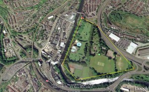
 Estimating is an essential skill in maths and science and one that is actually threatened by the continued use of calculators and digital measuring instruments. Turn the tables and use the Line and Path measurement tools on Google Earth (click on the ruler on the top bar) to estimate distances and areas.
Find a regular shaped feature on a map to start with – say a local football pitch – and ask pupils to measure it using the line and path function. From there they can go on to work out the area.
Once they have got the hang of it, you can do all sorts of things.
- Find out how far they live from the school. If they walk to school, ask them to estimate the time it takes them and calculate how fast they walk.
- Use GE to get approximate measurements of local geographical features.
- Add complexity by measuring an irregular shape – such as a park – and get them to work out the approximate perimeter and the approximate area by splitting the shape into other regular shapes they are able to calculate. (Tell them it is useful to do a rough sketch of the shape first to decide have they are going to divide it up.)
- Use it to look at the ratio of green space to built up areas in a given area as part of an environmental project. Or calculate the amount of woodland or arable land.
- If they are old enough to be able to triangulate the shape then they should be able to calculate the shape just using the path function on GE to get the perimeter.
- Do the same thing with upper age secondary children using calculus!
- Find towns or cities covering the same area and check out whether their populations are different – suggest reasons why.
- Find out the length of the sides of a square that has an area of one hectare and one acre. Find a piece of land they are familiar with and draw a hectare and an acre side by side. Encourage them to visualize the relative sizes.
- Guess the number of hectares / acres of particular fields and check them out with the path and line function.
(There are some online tools which makes something that has always been problematic very easy. This is one of them. The days of trundling around the school with a metre wheel may be long gone – Yay! )
Full lesson plan with detailed instructions on using Google Earth line and path function
This post is also available in: Romanian


 English
 Nederlands
 Deutsch
 Italiano
 Español
 Português
 Română
 Cymraeg
No comments yet.