Viewing 7 to 12 of 25 items
Archive | geography RSS feed for this section

Fly, fly away

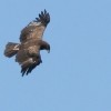
Age: 10 to 12 Goal: Find out about the flyway of the lesser spotted eagle using Google Earth. Description: The pupils should learn about the different landscapes the eagle crosses on its way and categories them. In addition to that they should learn how to use computer technology to gather and process data. What you need:  Full Article…

1

Virtual field trips revisited

I really like the Virtual field trips lesson, but I would recommend using the Google World Wonders Project as a starting point. With the Street View technology the Cultural Institute made a lot of Unesco heritage sites accessible, both from modern and ancient times. Of course your students can have a good look around, but  Full Article…

3

Investigating and acting on local environmental problems

Age: 12-15 years In this lesson, centered on environment and sustainability, students must identify, discuss and act on environmental issues that exist in the school area or in the places where they live. The seriousness of the environmental issues affecting our society needs citizens that are well informed and empowered to take appropriate actions about  Full Article…

0

Let’s go into the city

Lesson plan from Italy on Transport… During the morning students will have to carry out the following activities and/or purchases: A newspaper (news stand), A piece of pizza/snack (pizzeria), Exercise book (stationery store), A pair of socks (underwear), A map of the city (tourist office), Leaflet for trip (travel agency), Train schedule for trip (train  Full Article…

3

Virtual field trips

Google Street View is great for snooping around places you’ve never been to but did you know that you can sail down the Amazon, explore the Great Barrier Reef, look inside the Iwame Silver Mine, see Scott’s hut in Antarctica or wander around Stone Henge?   Other exciting images are this shipwreck off the coast of  Full Article…

2

How big is it? (Line and path maths)

Estimating is an essential skill in maths and science and one that is actually threatened by the continued use of calculators and digital measuring instruments. Turn the tables and use the Line and Path measurement tools on Google Earth (click on the ruler on the top bar) to estimate distances and areas. Find a regular  Full Article…

0